Hi everyone, and thanks for following our adventures, and for all your great comments and encouragement. Real-time blogging about Kili, the Great Migration and the Mountain Gorillas didn’t happen the way we intended, and it has taken us longer than we thought to get ourselves organized enough to catch up on the blog now that we are back home. Sorry about that! But we’re going to ‘turn the clock back’ on the blog and fill you in on our incredible time in Africa now… just pretend we’re still there! 🙂
Here’s a little context on the geography around Kilimanjaro and the route we hiked, the Rongai Route.

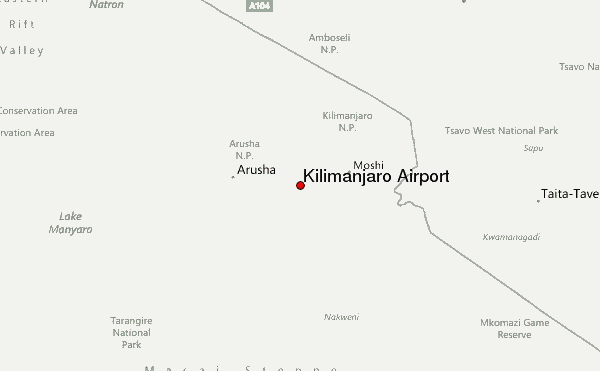
We flew from Johannesburg, South Africa through Dar es Salaam, Tanzania to Kilimanjaro International Airport outside of Arusha, Tanzania. The horrible terrorist attack that took place in Kenya while we were on the mountain happened in Nairobi, about 130 miles to the northwest of the mountain.
A little funny I found on the airport website…. don’t come with your snow skis… the closest ski resorts are a ways away… skiing in Iran anyone?!
 Ski Resorts close to Kilimanjaro International Airport:
| Closest ski resort | Afri-Ski (Lesotho) | 1840 miles S |
| Second closest ski resort | Tiffindell (South Africa) | 1976 miles S |
| Third closest ski resort | Matroosberg (South Africa) | 2356 miles S |
| Fourth closest ski resort | Sepidan Ski Resort (Iran (Islamic Republic of)) | 2530 miles NNE |
| Fifth closest ski resort | Pooladkaf Ski Resort (Iran (Islamic Republic of)) | 2533 miles NNE |

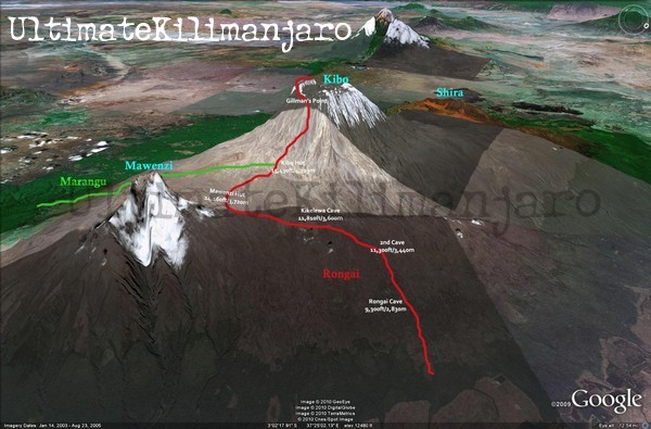
Zooming in on Kilimanjaro National Park, you can see the two routes we hiked along: we went up the Rongai Route on the north side of the mountain, and down the Marangu Route on the south. We loved this choice as it gave us the opportunity to see the very different scenery along the 2 routes, and because the Rongai route has relatively low traffic compared to the more crowded Marangu and Machame routes.

Mount Kilimanjaro is a dormant volcanic mountain and is composed of 3 volcanic cones: Kibo at 19,341 ft; Mawenzi at 16,893 ft; and Shira at 13,000 ft. Uhuru Peak is the highest summit on Kibo’s crater rim. One of the unexpected pleasures of the trip was Mawenzi Peak, which is a gorgeous mountain in its own right (more typically ‘mountain-peak’ shaped than Uhuru); it provided many spectacular early morning and moonscape views.
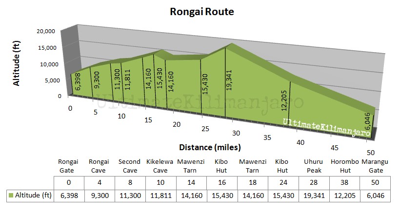
This profile provides a great overview of the 50 miles we covered over 7 days and the elevation gains and losses.
And lastly, for anyone wanting to dive into the details of our hikes, here you go 🙂

Our Kili Outfitter: Nature Discovery
Trip created by our travel pros, Khashana Adventure Travel. To see more view our other posts or visit their web site.